WITH CLIMATE CHANGE, RESEARCHERS ANALYZE THE TREND OF INCREASED FIRE RISK IN THE AMAZON FOREST

In an attempt to predict a scenario in which climate change affects regions mapped by the company – and based on the IPCC report – Quiron turned to its research team to project how the amplitude of areas exposed to the increase in surface temperature reflects in the increase of areas with greater exposure to the spread of untimely fire.
We know that the climate change scenarios we face severely condition wildfires and the expenses, around the world, to mitigate their effects. According to a report prepared by the United Nations Environment Program (UNEP), wildfires will increase by 50% by 2100. The alert falls mainly to government entities, which often channel most of their resources to reaction activities and fire response, not for fire preparation and prevention.
Whether governmental actors or private entities, small foresters, or even entrepreneurs in the sector, everyone seeks to find alternatives to deal with the direct and indirect effects of wildfires.
The United Nations publication reinforces the call for “two-thirds of the expenditures available today to be dedicated to planning, prevention, preparation and recovery”, with a maximum of “one third for the response”, that is, the confrontation and combat of the flames – when strictly necessary – in the field.
Another report, this time from the IPCC – Intergovernmental Panel on Climate Change, also from the UN – brings an even more frightening fact than that of the UNEP: the planet will face several inevitable climatic dangers with global warming of 1.5 °C. An even greater increase would generate additionally serious impacts, some even irreversible.
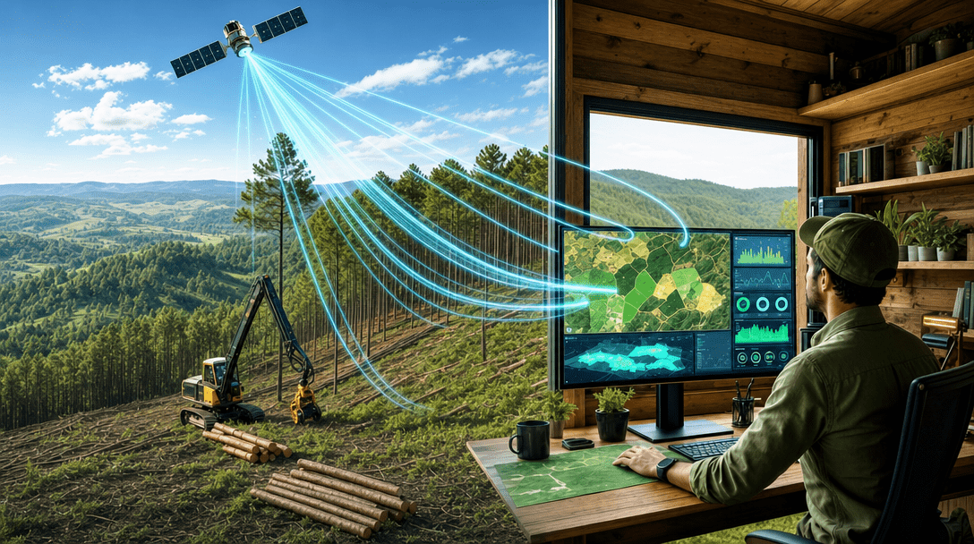
Specialist in fire prediction, with the Flareless solution, Quiron Digital has proprietary technology, through remote monitoring, allowing to mitigate losses from forest threats. The company has a research and development team with extensive know-how in the forestry area. Dedicated to working on improving products and innovations in image analysis, the team is led by Associate Professor at the Department of Forest Engineering at the University of the State of Santa Catarina (UDESC-CAV), Ph.D. in Geodetic Sciences, Marcos Schimalski. He leads a team that also has a Master in Forest Engineering from FURB, Adam Marques.
In an attempt to predict a scenario in which climate change affects regions already mapped by the company, Quiron turned to its research team to project how the amplitude of areas exposed to the increase in temperature ends up reflecting a lower local capacity to prevent the spread of the fire.

“We performed an extrapolation of the meteorological variables, simulating scenarios of temperature increase and a 7% increase for the other variables such as wind, relative humidity, and precipitation, which is the increased value cited by the IPCC report.”, commented Adam Marques.
Thus, in the predicted scenario, for each degree of temperature increase, the meteorological variability indices were increased by 7%. Despite the scenario predicting more rain, this would not make the areas less prone to burning, as the rains would be more voluminous and more spaced out over time.
“It is precisely the fact that the rain is concentrated in a single period that it will provide that the rest of the time is conducive to the fire occurrence. The distribution of rainfall will become more irregular. The increase in volume will be accompanied by poor distribution and a longer period of drought, so this does not help fighting fires,” said the researcher.
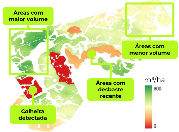
Check out some data from the study carried out:
The study can be interpreted by verifying the change in the meteorological risk class by period, considering the possible increases in surface temperature between 0 and 4 degrees Celsius.
In the case of large fires, in addition to the loss of vegetation, thick layers of accumulated soot are generated, where high levels of rain can cause large accumulations of material to move with great force, causing eventual ruptures and true land avalanches. Soot cannot retain the water that runs off the surface, unlike in a scenario where vegetation is present. Another point that facilitates ruptures of large masses is the roots of large trees that have burned, which during the rotting process, generate pockets of water accumulation that can saturate the soil and initiate landslides. Deforestation can also make the problem even worse, as these are situations that end up being more recurrent, says Adam.
“From a scenario in which there were no extreme rates for the spread of fire, we now indicate Very High or High risk, on the scale, greater than 50%, in a greater number of days. We will have scenarios of increasingly aggressive and recurring extremes. In this situation, even the dense forest can be vulnerable to fires. We did a simulation, based on data from the IPCC report, where the data demonstrates that even humid forests like the Amazon rainforest could have an even more expressive increase in fires if the worst scenarios are confirmed”, he said.

Professor Marcos Schimalski, team leader, commented on the work carried out, and the experience gained from research in the area. “The two decades of research in the forestry area have been translated into an algorithm for accurately predicting the danger of wildfires and, above all, with information that allows public and private managers to efficiently use available resources to prevent and fight wildfires. Flareless’ ability to continually learn adds the necessary dynamics so that the information provided by the Quiron platform is assertive and easy to use.”
“It is vitally important that we keep an eye on the construction of these scenarios. With the gradual increase in temperature, the increase in the risk of fires by more than 50% is evident, and this needs to be taken into account when planning public and private policies to prevent wildfires”, analyzes Diogo Machado, marketing director at Quiron Digital.
Quiron used data from Humaitá (AM), one of the largest municipalities in the country, in the Amazon Rainforest, where it had already carried out assessments between February 2020 and November 2021.
The IPCC report analyzes some regions as more critical than others depending on the distance and proximity of rivers and sea, for example, differently impacting areas more and less likely to face severe droughts and high fire risks.