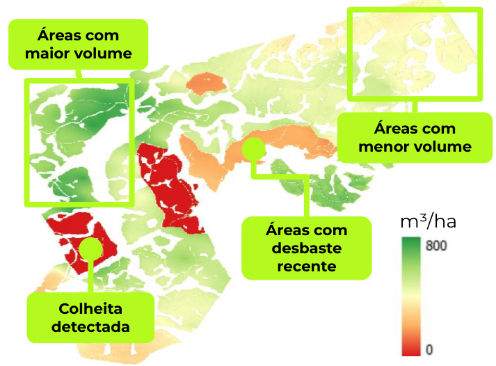
Climate change impacts ecosystems and forest-based activities. Actions such as forest conservation and restoration are essential to mitigate these impacts, as they absorb greenhouse gases and reduce global climate change.
Brazil is committed to reducing greenhouse gas emissions and minimizing the suppression of natural forests, with goals to cut emissions by 48% by 2025 and 53% by 2030.
Companies can offset their carbon emissions and take environmental responsibility through different strategies. These actions not only help mitigate environmental impact but also improve the company’s image and its relationship with investors and consumers concerning environmental issues. Strategies such as carbon offsetting, reducing direct emissions, and transparency in reporting are crucial to this goal.
Monitoring of Natural Capital and Forest Suppression
Actions such as the implementation of commercial forests, recovery of degraded areas, and the adoption of agroecological practices are effective in minimizing the climate crisis, promoting sustainability, and increasing the resilience of ecosystems. These actions also contribute to controlling forest activity, providing sustainable economic alternatives that can reduce pressure on natural forests. However, monitoring natural capital and forests is challenging. Remote sensing tools and artificial intelligence are effective in identifying suppressed areas, enabling efficient enforcement and prevention actions.
Open Monitoring Tools
Some of the land cover and use monitoring platforms used as data sources include MapBiomas, which stands out for analyzing deforestation and land use data in Brazil and Latin America using the Global Forest Watch (GFW) database. GFW is a global platform that monitors forests using satellite images from NASA and the European Space Agency. These tools are effective in identifying forest suppression or regeneration occurrences. However, the limitation of the algorithms and images used makes it difficult to distinguish, for example, whether a forest is native or a commercial forest that is being harvested or managed.
Due to this limitation, these tools alone cannot serve as the sole parameter for monitoring deforestation in native areas. Thus, they do not fully comply with new regulations, such as the European Union Deforestation Regulation (EUDR), which prohibits the importation of products into Europe from areas affected by any level of deforestation identified by December 2020, whether legal or illegal. Therefore, fieldwork can and should be complemented to avoid misinterpretation and ensure compliance with regulations.
An example of this imprecision was identified by Quiron Digital in samples of suppression monitoring for an area of interest located on the island of Sumatra, Indonesia, in a region of commercial oil palm plantations.
In the analysis conducted over an area of more than 14,000 hectares, comparing the reported data, Global Forest Watch presents values defined as false positives—when the online tool indicates deforestation data that did not actually occur—almost seven times higher than Quiron’s data.
On the other hand, false negatives, when the tool assesses that no deforestation has occurred but in practice did, are 46% lower in Quiron’s analysis.
It is important to highlight a difference between the concepts used and the evidence reported: while GFW only analyzes forest suppression, Quiron can also identify what is a commercial plantation and what is native forest. This distinction is crucial to be able to indicate, through scientifically-based analysis, whether the suppression of commercial plantations occurs as part of production management dynamics—when old trees are removed for new silvicultural plantings—or whether deforestation is happening, which occurs when trees are removed from natural formations.
This evidence of what type of plantation exists or what type of trees were removed is a unique feature offered by Quiron to its clients. Another important distinction is the interpretation of images regarding so-called false positives and false negatives in land cover and use monitoring. Data do not always provide evidence of what has or hasn’t happened in reality. Thus, we can consider that false positives are erroneous alarms (detecting something that doesn’t exist), while false negatives are failures to detect something real. In remote sensing, minimizing these errors is crucial for obtaining accurate and reliable results. The table below presents a comparative analysis of the results from Quiron versus GFW when comparing false positives and negatives.
| Comparative analysis | GFW (hectares) | QUIRON (hectares) |
| False positives (representation of deforestation that did not actually occur) | 144, 4 | 22,1 |
| False negatives (representation of no deforestation that actually occurred) | 156,3 | 83,7 |
The figure below presents a comparison of the suppression detections identified by GFW and Quiron:
| GLOBAL FOREST WATCH (GFW) | QUIRON |
 |
 |
The table below presents the area values for the suppression detections shown in the figure above:
| ANÁLISE COMPARATIVA | GFW (hectares) | Quiron (hectares) |
|
|
GFW cannot differentiate between types of forests | 151,93 |
|
|
GFW cannot differentiate between types of forests | 194,25 |
| Total area | 334,0 | 346,18 |
The Quiron solution, in addition to precisely detecting natural forest suppression, is able to identify more suppression areas (considering the year 2023). The table below presents Quiron’s differentials compared to GFW:
| Indicator | GFW | QUIRON |
| Resolution | Variable | 10 meters x 10 meters |
| Classification of suppressed forest | No classification | ✔️ |
| Artificial intelligence trained for each analyzed area of interest | No classification | ✔️ |
| Monitoring report | Generic, without customization or reference distinction | Customized |
| Area monitoring frequency | Variable, which can be annual or monthly | Weekly |
| Receipt of alerts | Generic, without customization or reference distinction | Customized |


